

Example app
The SDK repository
ships a full console under Example/. It is not a hello-world: it is the tool
the SDK is developed against, and the fastest way to see what a config change
actually does on a real device.
git clone https://github.com/dc-bgeo/ios-background-geolocation.gitcd ios-background-geolocation/Examplexcodegen generate # the .xcodeproj is generated, not committedopen BGeoExample.xcodeprojNo account or key is needed, and everything the app records — track, logs, geofences — stays on the device. Run it on a device for anything to do with background behaviour.
Three tabs
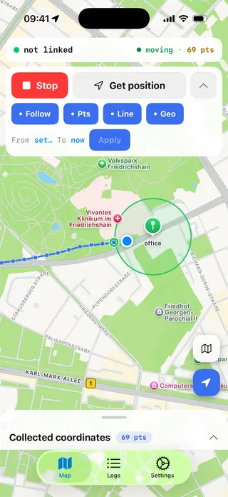
Map — the live track on MapKit, geofence circles and pins, and the controls that matter while walking around with a phone: Start/Stop, a one-shot Get position, layer toggles (Follow, points, polyline, geofences), and a from/to range picker that filters the track recorded on the device. Long-press the map to create a geofence; tap a pin to edit or delete it. Long tracks are drawn a page at a time, newest first, with a pager.
Logs — the merged event stream: your app’s lines and the engine’s own
diagnostics on one timeline, filtered by level, with follow-tail and clear.
This is the same data getLog() returns, which makes it a good way to learn
what the engine logs before you go looking for it in the field.
Settings — every working config key, grouped, applied immediately through
setConfig() and persisted as overrides. Rejected values surface their error
next to the field that failed rather than in an alert. Below the config there
is an engine panel: the getState() health fields, the upload-queue and log
counters, and the actions that have no other home — sync(), destroy queue,
upload/destroy log, changePace(), resetOdometer(),
requestTemporaryFullAccuracy().
The app does not configure the SDK’s HTTP uploader (url, logUrl,
authorization). To try uploads against your own endpoint, add those keys to
baseConfig in Sources/BGeoExampleApp.swift — see the
HTTP guide.
What to read in it
The example mirrors the React Native and Flutter examples file for file, so a concept you find here has a counterpart there. The parts worth reading if you are integrating:
| File | Why |
|---|---|
BGeoExampleApp.swift | Event subscriptions and ready() in the order that matters — subscribe first, then ready(). |
ConfigSchema.swift | Every config key with its real default — the same table as the Config reference, in code. |
Screens/MapScreen.swift | Drawing a live track without re-rendering it on every fix — the annotations are diffed and the current-position marker is moved, not replaced. |
Its own tests
xcodebuild test -scheme BGeoExample -destination 'platform=iOS Simulator,name=iPhone 17'The example’s non-UI logic — the config store, the history loader, the log pipeline — is unit-tested. Worth a look if you want a model for testing your own integration without a device in the loop.