

Geofencing
BGeo geofences are app-facing circular regions you define —
Transistor-shaped CRUD, distinct from the
engine’s own internal wake geofence used for
killed-app relaunch. You register them with an identifier, a centre, and a
radius; the SDK tells you (via onGeofence)
when the device enters, exits, or dwells inside one.
Geofences can be added, removed, and listed at any time — tracking does not
need to be running. OS-level monitoring, however, is only active while
tracking is started (start()):
stop() unregisters every app-facing region from the OS (the persisted set
is untouched), and start() re-registers them. Forcing a motion-state change
with changePace() has no
effect on geofence monitoring either way — only tracking start/stop does.
Adding and removing geofences
Full method signatures, parameters, and return types are documented on the
Methods reference; this
section covers the fields and the validation rules behind INVALID_GEOFENCE.
A geofence rejects with INVALID_GEOFENCE unless all of the following hold:
identifieris a non-empty string.radiusis a finite number greater than0.latitudeis finite and within-90..90.longitudeis finite and within-180..180.- at least one of
notifyOnEntry,notifyOnExit,notifyOnDwellistrue(a geofence that notifies on nothing is rejected rather than silently registered as dead weight).
await BackgroundGeolocation.addGeofence({ identifier: 'home', radius: 150, latitude: 52.2297, longitude: 21.0122, notifyOnEntry: true, notifyOnExit: true, notifyOnDwell: true, loiteringDelay: 300000, // 5 minutes, required for a DWELL transition extras: { kind: 'home', label: 'Home' },});extras is an arbitrary object you attach to the geofence; it is never
inspected by the SDK and is echoed back verbatim on every
GeofenceEvent so you
can identify which geofence fired without a lookup.
Adding a geofence whose identifier already exists overwrites it in
place — new radius, coordinates, notify flags, and extras replace the old
ones, and if it’s currently OS-registered it’s re-registered with the fresh
values. There is no separate “update” call.
addGeofences() is the bulk form — same validation, same overwrite
semantics, applied to a whole array in one native round-trip:
await BackgroundGeolocation.addGeofences([ { identifier: 'home', radius: 150, latitude: 52.2297, longitude: 21.0122, notifyOnEntry: true, notifyOnExit: true }, { identifier: 'office', radius: 100, latitude: 52.2319, longitude: 21.0067, notifyOnEntry: true, notifyOnExit: true }, { identifier: 'school', radius: 120, latitude: 52.2189, longitude: 21.0289, notifyOnEntry: true, notifyOnDwell: true, loiteringDelay: 600000 },]);Removing is either targeted or total — there is no “remove several by id” call:
await BackgroundGeolocation.removeGeofence('office'); // just this one
await BackgroundGeolocation.removeGeofences(); // ALL geofences, whole persisted set
getGeofences() and geofenceExists() read the full persisted set — not
just the proximity-sliced subset currently registered with the OS (see
Proximity slicing below):
const all = await BackgroundGeolocation.getGeofences();const hasHome = await BackgroundGeolocation.geofenceExists('home');Radius guidance
There’s no platform-enforced minimum radius in this SDK — any value greater
than 0 passes validation. In practice, a larger radius makes ENTER/EXIT
more reliable: GPS accuracy jitter near a small boundary can produce spurious
crossings, especially indoors or downtown. A tighter radius gives more
precise triggering at the cost of occasional missed or bouncing transitions.
Pick the radius per use case rather than a single fixed number.
One concrete platform constraint worth knowing: iOS clamps every region’s
radius to CLLocationManager.maximumRegionMonitoringDistance at
registration time, silently shrinking an oversized radius to that cap.
Android has no equivalent clamp.
Geofence events: ENTER, EXIT, DWELL
Transitions are delivered through onGeofence
as a GeofenceEvent —
see that reference for the full payload shape. This section covers only the
semantics of the three actions.
- ENTER fires when the device crosses into the region, if
notifyOnEntryistrue. - EXIT fires when the device crosses back out, if
notifyOnExitistrue. - DWELL fires after the device has remained inside the region for at
least
loiteringDelaymilliseconds, ifnotifyOnDwellistrue. AnotifyOnDwellgeofence without a positiveloiteringDelayfalls back to a 5-minute (300000) default rather than disabling DWELL.
DWELL is implemented differently per platform, though the observed event is identical:
- Android uses the OS’s own native dwell detection
(
Geofence.GEOFENCE_TRANSITION_DWELL+setLoiteringDelay) — Play Services tracks the loiter internally and delivers the transition. - iOS has no native dwell transition, so the SDK emulates it: on ENTER,
it records the entry time and arms a timer for
loiteringDelay; EXIT cancels the pending DWELL. Because a timer dies if the app is suspended before it fires, the pending entry is also re-checked on every accepted location fix and on wake — so a DWELL can arrive a little late on iOS, but it always arrives once the device has genuinely stayed long enough and is still inside on the next check.
A DWELL-only geofence (notifyOnDwell: true, notifyOnEntry/notifyOnExit
both omitted or false) still requires entry monitoring under the hood to
establish the loiter baseline on both platforms, but you won’t receive an
ENTER event for it — only the eventual DWELL.
Proximity slicing
Both iOS and Android impose a hard cap on how many geofences an app can have
registered with the OS at once — 11 on iOS, 99 on Android (each
platform’s real budget is 20 / 100, minus one region the SDK’s own stationary
wake geofence occupies and, on iOS, minus the wake ring
of 8 satellites by default — set wakeRegionRingCount: 0 to get all 19 back). Persisted geofences aren’t limited to that count —
you can store as many as you like — but only a subset can be live with the
OS simultaneously. The SDK bridges this gap with proximity slicing:
- Of all persisted geofences, only those within
geofenceProximityRadiusmetres of the device’s last accepted fix are candidates for OS registration (default1000m). - Candidates are sorted by distance and the nearest ones are registered, up
to the platform budget — or a smaller number if you set
maxMonitoredGeofencesto deliberately stay under budget. - On every accepted location fix, the slice is re-evaluated: geofences that fell out of range are unregistered and newly-in-range ones are registered, keeping the OS-registered set centred on where the device actually is.
- Before any fix has been received (cold start), the SDK falls back to registering the first geofences in persisted order, re-slicing as soon as the first fix arrives.
flowchart LR
    store[(All persisted geofences)] --> filter[Proximity filter\nwithin geofenceProximityRadius\nof last fix]
    filter --> sort[Sort by distance]
    sort --> cap[Cap at min of\nmaxMonitoredGeofences and\nplatform budget: 11 iOS / 99 Android]
    cap --> registered[OS-registered subset]
    registered -.-> change[onGeofencesChange: on / off delta]
    fix[New accepted fix] -.-> filter
onGeofencesChange
tells you exactly which geofences are in the active, OS-registered set at
any moment: it’s a delta, not the full set — on lists geofences newly
registered, off lists geofences just unregistered, fired whenever the
slice rotates. See GeofencesChangeEvent
for the payload shape.
Synthetic ENTER on registration
geofenceInitialTriggerEntry
(default true) requests a synthetic ENTER for any geofence that turns out
to already contain the device at the moment it’s registered with the OS
(iOS requestStateForRegion, Android INITIAL_TRIGGER_ENTER). Without it,
a geofence you’re already standing inside when it’s added — or when
proximity slicing brings it into the OS-registered set — would otherwise
never fire ENTER until you leave and re-enter. Set it false if you only
want events for boundary crossings that happen after registration.
Persistence
Geofences persist in the SDK’s own SQLite database (bgeo.db, in the
geofences table) on both platforms, alongside the location queue — see the
data pipeline concept.
They survive app restarts and device reboots: the full set is reloaded and
re-registered with the OS the next time tracking starts, with no need to
call addGeofence() again after every launch.
Geofence ENTER/EXIT/DWELL transitions ride the same upload queue as
location records rather than a separate channel — a transition is queued and
uploaded exactly like a
location fix, including delivery while the app was killed at the moment it
happened. Your server receives it as a location-shaped record with an event
field identifying it as a geofence transition, not a plain location.
Migration note: one-time region sweep (iOS)
Since engine 0.15.2 the SDK registers its app-facing geofences with Core
Location under com.bgeo.gf.<identifier> (the identifiers you pass and
receive are unchanged) so that it can tell its own regions apart from anything
else in locationd. On the first launch of a build containing this change
the engine stops every monitored region that is not com.bgeo.* exactly
once — orphans left by older engine versions, but also any CLRegion your app
monitors with its own CLLocationManager. If you do, re-register those regions
after that first launch; one queued transition may be lost to the sweep.
Subsequent launches never touch non-com.bgeo.* regions. Downgrading to an
older engine leaves the com.bgeo.gf.* regions in place until the newer build
runs again.
Try it in the example app
The example app lets you create a geofence by long-pressing anywhere on the map, which opens a form pre-filled with the tapped coordinates.
The form takes an identifier, a radius in metres, and a switch per transition
(ENTER, EXIT, DWELL); saving it registers the geofence and draws it on
the map as a circle, with the Geo layer toggle controlling whether
registered geofences are drawn at all.
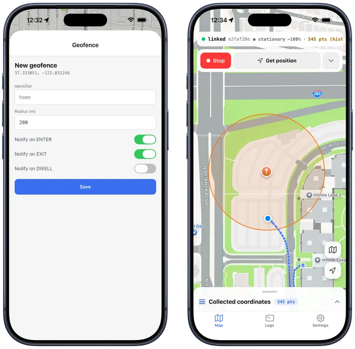
iOS — the creation form, and the saved geofence on the map.
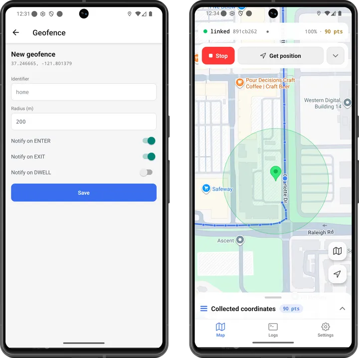
Android — the same flow.